


Save time and improve your modelling workflows using MIKE Zero’s upgraded editors and viewers. Take advantage of new keyboard shortcuts and themes, improved tabbing, tear off and cascade functionality plus easier access to User Guides and Scientific Documentation.
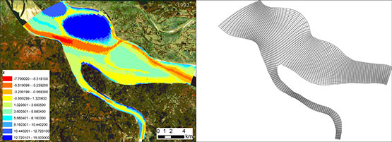
A complex pre-flood survey of the Mekong River (Cambodia) reveals the flow will go to the lake on the rising limb and empty to the falling limb. Observed flow fields to the left and simulated to the right.
With the MIKE 21C Hydrodynamic (HD) module, you can calculate flow fields in response to a variety of forcing functions, such as prescribed water levels or flows at open model boundaries
- Compute water levels and flow velocities on a curvilinear or rectangular grid covering the study area by solving the St. Venant equations
- Perform long-term simulations with the highly efficient model solver
- Model hydraulic structures with your choice of dynamic or quasi-steady solutions

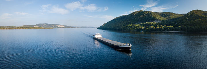
Point bar with vegetation on the Danube River in Serbia.
With MIKE 21C’s specialised Helical Flow module, you can accurately describe the time and space lag in the development of the helical flow to analyse bend scour, confluence scour and char build-up and migration. Helical flow develops in channel bends due to curved streamlines. While it generally does not have a strong influence on general flow patterns in rivers with large width/depth ratios, it can have a significant influence on sediment transport direction and hence morphological changes (e.g. sand bars).
With MIKE 21C’s comprehensive Sediment Transport (ST) module designed for sediment transport and river morphology dynamics, you can model:
-
-
- Helical flow, bank erosion, bed scour
- Sediment transport for sand and gravel
- Bed load with secondary flow effects
- Suspended load with non-uniform concentration profile variation
- Multiple sediment fractions using cohesive and non-cohesive sediment models
- Individual sediment fractions for highly customisable parameterisation
-
Single fraction sediment models suffice in cases where the standard deviation of the particle size distribution is sufficiently low. The classic case being a low land river with well mixed sand, and it involves using e.g. the median grain size.
Graded sediment models are required for situations where the sediment cannot be described with one single size class. For such models, a number of discrete sizes are defined, which represent the known grain sizes involved in the considered problem. MIKE 21C supports up to 32 sediment fractions and up to 16 bed layers.
Graded sediment models are far more complex than single fraction models, requiring:
-
-
- Sediment budget for each size class, e.g. distribute total sediment inflows to the fractions
- Local distribution of size classes in the bed, can include vertical distribution in the bed
- Sediment transport models can be defined individually for each size class
-
With MIKE 21C, you can accurately calculate scour and deposition including the effect of supply-limited sediment layers. Simulate the downstream migration of fine material on a coarse riverbed or represent non-erodible (protected) riverbed areas in the modelling domain.

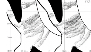
Simulation of a braided river starting from plane longitudinally sloping bed (Jamuna River, Bangladesh).
The Planform module of MIKE 21C allows you to accurately represent lateral processes in morphological models. Calculate bank erosion for inclusion in the riverbed sediment budget or update the curvilinear grid to account for movement in the bank line. You can also reproduce the chaotic behaviour of a multi-channel river such as a braided river.


With MIKE 21C, each sediment fraction can have its own sediment transport modes and specified formulas. Cohesive sediment fractions are handled as suspended load with traditional erosion and deposition functions, while non-cohesive sediment fractions can have bed-load and suspended load set individually. Several non-cohesive sediment transport formulas are also available including: Engelund-Hansen, van Rijn, Engelund-Fredsøe, Meyer-Peter & Müller, Smart-Jaeggi, Yang, Wilcock & Crowe, Garcia & Parker, Parker, Ackers & White and Lane-Kalinske.
Bed-load is always considered in equilibrium and includes the effect of helical flow and bed slope.
All suspended sediment transport, including cohesive and non-cohesive sediment fractions, are also uniquely handled with Advection-Dispersion (AD) equations. These are specific for each fraction due to the individual convective fluxes associated with helical flow and non-uniform concentration profiles, as well as specific dispersion coefficients. The AD equations are solved using an implicit scheme.
With MIKE 21C’s Quasi-Steady approach, you can conduct morphological simulations with time-varying boundary conditions covering several years or even decades. Benefit from a significant increase in computational speed where the hydrodynamics are considered quasi-steady, for example where flow fields only change due to morphological changes and/or due to slow changes in boundary conditions.
Defining a boundary conforming curvilinear grid allows highly efficient use of the grid points to describe the channel, because the grid lines follow the bank lines, a 2D river model can easily cover a 150 km stretch.
Ease the task of data input, analysis and presentation of simulation results via an integrated work environment available through the standard MIKE 21 Pre- and Postprocessor tools embedded in MIKE 21C.
With the Curvilinear Discharge Calculation Tool, you can calculate the discharge of water or sediment through the model area at selected cross-sections.
With the built-in Result Viewer, you can display a number of result files of different format and from different modelling systems in the same plot provided all result files are geo-referenced according to the same coordinate system.
For morphological simulations, the use of animations to visualise results is highly important. MIKE 21C allows you to animate results on the screen using online control buttons for play, pause, play 1 step, rewind, go to end and more. In addition, video files can also be created.
MIKE 21C inputs and outputs are readily accessible by your own code in e.g. Matlab, Python, and C# using MIKE SDK. This capability allows for custom tool development to support the unique needs of your projects.
MIKE SDK offers methods for reading and writing the binary result files from MIKE 21C, especially the dfs2 files which are often used when post-processing results. Code that reads the result dfs2 files and grids are easily written based on the examples under the SDK installation. Post-processing typically involves integration over areas or time, and calculation of derived results.
You can now access MIKE 21C on Azure Marketplace, where you can start modelling in the cloud with no hardware limitation in four simple steps. Learn more