Full spectrum sand transport modelling
Assess the potential impact of erosion and sedimentation on coastal, estuarine and offshore infrastructure to support planning, design and mitigation strategies
Why MIKE 21/3 Sand Transport?
Uniquely calculate sand transport due to pure currents or combined waves and currents
With this pioneering intra-wave sand transport model, you can calculate sand transport due to the combined effect of waves and currents. Accurately describe the movement of sand in the model with the integrated wave boundary layer approach. You can even include lag effects from the flow and suspended load in the morphological development when basing calculations on pure currents.
Play Video
Simulation of the morphological change in channel bathymetry due to a new jetty
Play Video
Watch how the add-on Shoreline Morphology module can be used to forecast port sedimentation over a multi-year period
Model complex sediment transport processes and shoreline morphology with ease
The erosion and deposition of sand creates challenges for those tasked with beach development and conservation, maintaining harbour depths and controlling sediment spread from dredging operations. By incorporating the add-on shoreline module, MIKE 21 Shoreline Morphology, you can make long-term predictions of shoreline morphology and better understand the impact of sedimentation on complex coastal structures.
Perform dynamic coupled modelling including hydrodynamics and waves
By coupling MIKE 21/3 Sand Transport with MIKE 21/3 Hydrodynamics and MIKE 21 Spectral Waves, you can analyse sediment transport patterns around structures or near tidal inlets. Take advantage of an advanced sediment transport model capable of calculating transport rates under combined current and waves (breaking or unbroken) at arbitrary angles. Use the bed update feature of MIKE 21 Sand Transport to simulate morphological response to structures and under natural conditions.
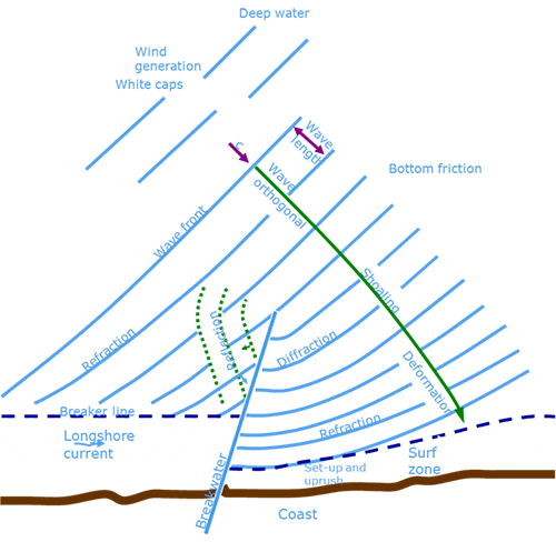
Nearshore processes that influence sediment transport rates
Rely on MIKE 21/3 Sand Transport to support key initiatives

Coastal Engineering
Assess the impact of erosion and sedimentation on a major coastal project such as a port or coastal protection scheme.
Port Design
Inform the design of sediment management strategies based on current, wave and sediment transport data in key port areas.

Oil & Gas
Support design and mitigation efforts by simulating the effects of erosion over buried (subsea) pipelines.

Coastal & Offshore Constructors
Determine the potential impact of sedimentation caused by offshore or coastal structures as part of an Environmental Impact Assessment.
Dredging
Determine the amount of dredging required in a navigation channel to maintain a certain depth.
No in-house modellers?
DHI offers comprehensive modelling and consulting services in support of coastal and estuarine infrastructure project development and environmental impact mitigation.
See how this software provides valuable insight
Featured software subscription package
Coastal Engineering
This affordable subscription package features some of our best industry-recognised applications to support your coastal engineering studies including MIKE 21/3 Sand Transport, LITPACK, MIKE 21 Spectral Waves and more!
Additional capabilities & unique features
Experience enhanced capabilities for 3D Sand Transport calculations to boost modelling precision and efficiency. With improvements in the Kovaks and Parker implementation, the introduction of a bed load formula following the Engelund & Fredsoe Extended Formula, a new bed boundary condition, and an advanced bed friction profile in the Hydrodynamics module after Van Driest, you can achieve more accurate results and make more informed decisions.
Save time and improve your modelling workflows using MIKE Zero’s upgraded editors and viewers. Take advantage of new keyboard shortcuts and themes, improved tabbing, tear off and cascade functionality plus easier access to User Guides and Scientific Documentation.
MIKE Zero, DHI’s fully Windows integrated graphical user interface, is now better than ever and comes standard with all MIKE 21/3 software. Enjoy easy access to new MIKE Cloud applications and Cloud-enhanced functionality, plus an extended set of MIKE tools within theme-based (rather than product-based) interactive workflows. Ensure important model components such as sources and structures stay at the forefront with a new interactive, customisable floating mapping window. Lastly, the updated tabbing functionality will help you work in a more organised and efficient manner.
Use MIKE 21/3 Sand Transport to determine the consequences of different orientations of a beach, the division of a beach into sections and possible structures to support the beach and expected maintenance. Simulations can be designed to cover a period of one or more years and to account for extreme storm conditions.
A key component of an Environmental Impact Assessment is the ability to demonstrate a solid understanding of the impact of a project upon regional and local morphological processes, ecology and habitats including mangroves, sea grass beds, organisms and endangered species. With MIKE 21/3 Sand Transport, you can effectively describe, assess and simulate the present and future coastal morphology and dominant coastal processes.
Coastal environments are transient and continuously reshaped by the natural forces of waves, tides, storm surges, erosion and deposition. To be sustainable, coastal development requires a clear understanding of, and respect for, these natural processes. MIKE 21/3 Sand Transport can be used to identify the best solutions to mitigate the impact of erosion on beaches and at ports and tidal inlets.
Use the Sand Transport module on all scales, from regional areas (10 kilometres) to local areas around coastal structures, where resolutions down to metres are needed. The software is designed to span the gap from the river to the coastal zone.
Take advantage of this capability using the built-in Dune Erosion Model.
You may choose to include a varying layer thickness as start condition for the simulation. This option is useful when simulating sand transport in areas with rock bed present (i.e. cases with non-erodible bed and limited sand supply).
Point sources of suspended sediment are important in many applications such as the release of sediments from rivers, intakes and outlets from cooling water or desalination plants. In MIKE 21/3 Sand Transport, the source concentrations of each component in every sources point can be specified individually as either specified concentration or excess concentration.
Specify bed level sources to simulate the effect of nourishments or dredging on morphology. You can also specify maintenance dredging to keep a certain water depth in a navigation channel and to dispose the dredged sediment in a specific area.
MIKE 21/3 Sand Transport takes advantage of the efficient parallelisation techniques implemented in MIKE 21 for the use of multiple cores and GPUs. Special techniques have also been developed to enhance calculation speed within the morphological modelling.
Let's get started
Learn how your project can benefit from this full spectrum sand transport modelling software.
Complete this form and we will be in touch soon.
Complete this form and we will be in touch soon.